Methodist Meeting House Historical Site Needs Your Voice and Support Ahead of Destruction

The date is October 7th, 2018. On October 17th, 2018 at 6:30 at night the Hillsboro Landmarks Advisory Committee will hold a meeting at the first floor of the Civic Center located at 150 East Main Street, Hillsboro, Oregon. At this meeting plans for a monument for the incredibly important Historical location known as the Methodist Meeting House will be discussed.

MMH MAIN.png

Your attendance is requested if you are at all able to make it there.

The world’s largest developer of Industrial Parks, Majestic Development, has plans to build on this site and to excavate the land of the Methodist Meeting House which includes at least 5 graves, those all belonging to the children of Joseph and Virginia Meek; some of the initial settlers and leaders in the Oregon country.

This is a complex yet simple story. Perhaps watching a video will help explain this to you all better. Spend 3 minutes on this as needed.

Here is a timeline Summary about the Methodist Meeting House:

Methodist Meeting House Timeline

We know the site is incredibly important and while we can not bring back the past we have two groups leading the way to protect the site; the Meek Plains Historians and the Five Oaks Discovery Coalition.

In 2004 Tom Hughes, who was the Mayor of HIllsboro, on behalf of the City, agreed to a contract with the State of Oregon regarding this historic site. In essence Hillsboro wanted more land for Industrial Development to be taken from protected farm land and converted to Industrial land. The City and landowners also wanted to get the SIPS program treatment for the sites , which allows for Millions in tax giveaways. In order to get the zone change and the tax breaks for corporations, the land owners becoming multi-millionaires at the same time, Mayor Hughes wrote a letter to the State of Oregon thereby sealing the deal.

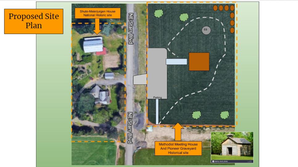
That letter included the identification of a 1 acre lot upon which a task force and the city believed the Methodist Meeting House was located. The letter also assured that Hillsboro would require the landowners, during the time of development, to require a Monument be built upon the land commemorating the Methoidist Meeting House and the associated graves and that the Hillsboro Landmarks Advisory Comittee would approve the design for such a Monument. That 1 acre lot is as show below:

The site of the Methodist Meeting house is directly across from the Shute-Meierjurgen House, a National Historic Site, which is located at 4826 NE Starr Blvd., Hillsboro, Oregon 97124.

The site of the Methodist Meeting house is directly across from the Shute-Meierjurgen House, a National Historic Site, which is located at 4826 NE Starr Blvd., Hillsboro, Oregon 97124.

HERE IS WHERE WE ARE NOW

At this juncture the Developer, Majestic Westmark, has applied for about 850,000 SF of buildings to be placed over the site of the Methodist Meeting House. They are NOT RECOGNIZING THE MMH SITE and at this time they DO NOT INTEND to honor the City of Hillsboro’s laws and regulations as provided for in our Comprehensive Codes.

YOU CAN GET INVOLVED AND HAVE YOUR VOICE HEARD

SIGN THE PETITION ONLINE

Come to the Hillsboro Landmarks Advisory Committe Meeting October 7th at 6:30 PM at the Hillsboro Civic Center

Follow Our Facebook Page For Future Hearings and Meet Ups!


Our groups are in this for the long haul and will do whatever we can to watch over the site and make sure a good outcome is arrived at. The site will hopefully have a future long after we are all gone and will become a place for future generations to come and learn about our early history. We hope thay will understand the importance of the Tualatin Plains and the Methodiost Meeting House, the early pioneers, and the role that the native poeple from all tribes played in our territory and statehood during this time of survival and change.

Thank you all for your support!


Oregon Journal Guide To Hillsboro, Oregon History Unearthed

Thanks to our good friend Judy Gates Goldman, great granddaughter of Joe and Virginia Meek, we now have a copy of a great piece of Hillsboro History.  The Oregon Journal was the leading paper in Oregon for decades and was eventually run out of business by The Oregonian among others.  But sometime in the 1960's they ran an Insert featuring early Washington County History.  While there is no date on the 6 Page document Judy says it was from the 1960's and like so many things that have caught her eye she saved it!  Here is a copy of that fine document via pictures and we will try and get it in a form more easily read soon!  Thanks to Judy for saving this and we hope you enjoy it!

1.jpg
2.jpg
3.jpg
4.jpg
5.jpg
6.jpg
7.jpg
8.jpg
9.jpg

Landing A Treasure From The 1850's William Wilson DLC Highlights Battle To Save The Tualatin Plains

If you knew you were watching something important be destroyed forever you would try to stop that, wouldn't you?  What if that something was so rich in history, and so important to the world, that loosing it could signal the end of all you knew?  Would you care then?

I hope so.  Because today as I drove off from the farm of Larry Duyck out on NW Roy Road I realized, more than I ever have, what the cost of rampant development here in the Tualatin Plains can cost us all.  The Duyck Farm was started in 1907 and remains today in the capable hands of the 3rd (Larry Duyck) and the 4th generation (Jacque Duyck Jones; daughter).  The farm is stunningly beautiful with the classic farmhouse and barns setting the scene for acres of kotata blackberries, blueberries, and other rotation crops which are bursting from the ground this Spring.  Irrigation systems are in place and there is a palpable blend of modern machinery and timeless farming know how.  I hope it will be another productive year on the farm for this family whose name is synonymous with Washington County and productive sustainable farming.

15,000 years ago, as the Ice Age was ending, giant Lake Missoula in Western Montana broke through a massive ice damn and sent torrents of water, rock, silt, gravel, and anything and everything in its path towards the Columbia Basin.  Imagine water 1,000 times the volume of the Columbia River coursing through our Region and making valleys and lakes and gaps wherever it chose to do so.  This went on for hundreds of years and these floods created the land we know today.  Through the Willamette River, Lake Oswego, and Tualatin River gaps, coarsed billions of tons of fine silt from Eastern Washington and beyond.  It filled the Tualatin Valley and Tualatin Plains and settled here as the waters receded against the Tualatin, Coastal, and Chehalem Mountain Ranges.  What was left was arguably the greatest farmland in the world.  Here we are, us locals, in the middle of the most productive land on Earth and yet most of us do not even know it.  The Duyck's know it and have fought to protect the very asset that supports them and their neighbors.

Surrounded by hills and mountains (red) the Tualatin Valley was one of the few places where the Missoula Floods deposited so much rich soil and silt making for incredible farmland.

Surrounded by hills and mountains (red) the Tualatin Valley was one of the few places where the Missoula Floods deposited so much rich soil and silt making for incredible farmland.

History Took Me Out...   What led me out to the Western end of the Tualatin Plains today was my interest in History; the history of our valley and our people.  Granted most of you reading this are new to the Valley.  But pay attention because you are going to play a bigger role in what happens to people like the Duyck family than those of us who have been here for decades and that is because you outnumber us 3 to 1.  In fact, 2 out of 3 people now in Washington County have not been here longer than 20 or 30 years. 

Today I came looking to preserve some of the historical past of William and Polly (Mills) Wilson who settled the 642.50-acre land claim that the Duyck's farm is located upon.  The Wilson's came over in 1843 with their children John,  Caroline, and Rachel.  Reverend Marcus Whitman acted as their guide and brought them much of the way along with  3 other pioneer families (Constable's, Arthurs, & Mills).  Their arrival was 4 years prior to the opening of the Oregon Trail and they could count on 1 hand the neighbors they could see on the clearest of days from their farm. 

In 1847 the Oregon Trail officially opened and thousands came pouring into the Oregon Territory chasing the promise of free fertile farmland.  In that same year Marcus Whitman and his wife Narcissa and family, along with many others, were massacred in Walla Walla by the Cayuse Indians who were reacting to the death and destruction put upon them by the White man's diseases and influences.

Seen here in the 1851 Survey map is the William Wilson Claim of 642.50 Acres and the surveyor clearly is showing the location of their home and barn.  Some of their neighbors names are well known today.

Seen here in the 1851 Survey map is the William Wilson Claim of 642.50 Acres and the surveyor clearly is showing the location of their home and barn.  Some of their neighbors names are well known today.

The Duyck's recently took down a barn - a very very old barn.  It had to go but when it did they made sure to have as much of the wood as possible reused and repurposed.  Out there on the farm was a large pile of huge log floor beams and it occurred to me that reusing wood from our valley as old as this wood is was the right thing to do.  The Wilson's may have cut this wood, built the barn, and sat under the shade of these trees.  God knows the Duyck's used this barn for 4 generations and the fact that there was something that old of that much use to these families meant that the historian in me wanted in.  


The Bigger Story-  

Today I moved the massive beams.  They are truly wonderful and we will be making some log benches out of them over the Summer.  Larry Duyck helped me move them and we had a nice chat.  A small part of that 170 plus years of History from the Wilson-Duyck farm left with me today and we will cherish it and tell its story for decades to come.

As I left Roy Road today with my bounty I realized how unchanged that area is.  The reason for that is partly geography - growth and our "wonderful" Urban Growth have not come knocking yet.  But just as big of a reason is that Larry and his family, as well as some others, have fought for decades to have this legacy protected.  

Heading North from my home in Orenco is the East end of the Tualatin Plains.  It was 45 years ago when my buddies and I roamed the vacant farms and creek bottoms of this area, free from disturbances, hunting squirrels and chasing girls.  People never thought it would change.  But it did.  Today we cannot move here at rush hour.  The farms are all gone.  So are the original people.  And history?  With the exception of yours truly and a few others, there is no sense of history here. 

The Intel Ronler Acres Fab has now covered over 100 acres of Prime Farm land on the East end of the Tualatin Plains taking out native american and local history as it went in.

The Intel Ronler Acres Fab has now covered over 100 acres of Prime Farm land on the East end of the Tualatin Plains taking out native american and local history as it went in.

As I drove past INTEL RONLER ACRES heading to the Duyck's Farm melancholy overtook me.  If your local you understand this feeling when you travel around this area.  Another mile West along my route is the Shute Road Industrial Park and the Majestic Business Park; now home to Amazon.  This area was bucolic farm land not even a decade ago.  It was all a part of the Tualatin Plains that the Missoula Floods had created.  But we needed it for the "High Paying Jobs" that were coming to the Valley.

Looking West towards the Duyck Farm we see the rapid expansion of the Industrial parks and Gas and Chemical storage faciliies.

Looking West towards the Duyck Farm we see the rapid expansion of the Industrial parks and Gas and Chemical storage faciliies.

Even further West I rolled past the Historic Shute Farm, which has just been added to the National Historic Registry thanks to the hard work of the Haag Family who have been there since the 1960's.  Change is coming all around them too as it rolls West towards the Wilson-Duyck Farm.  Across the street from the Shute House in an ancient field, the bodies of 5 children of Colonel Joe and Virginia Meek are buried.   Colonel Meek and his Nez Perce Wife, Virginia, settled in the Tualatin Plains just 3 years before the Wilson's did (1840).  They likely knew each other and all of them made this valley the great place that it is.  

In the coming months, you will all hear about the Meek children.  It seems that the Majestic Development group has decided to excavate the site where the City believes the Meek children and the adjacent Methodist Meeting House historic site are located to make way for a new 800,000 SF Warehouse and parking lot with drainage pond.  This statement is based upon the plans that they have turned in to the City of Hillsboro as shown below.

This proposal to Develop 45 plus acres in the Tualatin Plains was submitted to the City of Hillsboro recently by a consultant for Majestic showing a massive drainage pond being excavated where the Methodist Meeting House and the bodies of the Meek C…

This proposal to Develop 45 plus acres in the Tualatin Plains was submitted to the City of Hillsboro recently by a consultant for Majestic showing a massive drainage pond being excavated where the Methodist Meeting House and the bodies of the Meek Children have been documented to have been buried.

This aerial photo shows the location that the City of HIllsboro in 2004 said they believed was the probable location of the Methodist Meeting House and burial griounds.  The Shute home is located just to the west.

This aerial photo shows the location that the City of HIllsboro in 2004 said they believed was the probable location of the Methodist Meeting House and burial griounds.  The Shute home is located just to the west.

In Case the Point is Muddled or Subtle -

As I continued West the facts are self-evident.  Traffic and development are going on all the way West to the City of North Plains (OR) which just so happens to be the 1/2 way point from my home on the East end of the Tualatin Plains, to the West end where I was going to get the logs.

We are losing our valley.  We are losing our farms.  We are losing our countryside and perspective as to who we are and how we fit in.

Larry Duyck and his daughter know how they fit in.  And they know if they do not work hard to protect their farm, growth can and will come.  Others scoff and say that sort of thinking is ridiculous.  But the proof is everywhere.  It is coming from the East and it is heading to West.

The Tualatin Plains are being crowded out and built over quickly these days in North Hillsboro and growth is quickly coming to the West end.  The richness of the land is obvious to anyone driving through it or who see the pacthwork fo large far…

The Tualatin Plains are being crowded out and built over quickly these days in North Hillsboro and growth is quickly coming to the West end.  The richness of the land is obvious to anyone driving through it or who see the pacthwork fo large farms from above.


The reasons that our farmland is being plowed under were promoted primarilty as a way to provide much needed Industrial land for "High Paying" jobs.  INTEL did create those jobs but they are taking our Water at a rate that threatens our own supplies.  And that was over a decade ago.  Since that time we have had Data Centers erected which employ virtually no one while using massive amounts of power.  We also have Top Golf and those low paying jobs.  And of course there is Amazon who recently moved into the Majestic business Park and those jobs are low paying as well.

Outsiders, foreign investors, non-Oregonians, and others are coming to our Valley, developing the land, and taking all the cream off the top as they head to their next conquest.  They higher slick consultants who spin a good line of BS and talk in codes and get tax giveaways in a smugness that rivals anyone.  But the facts are right in front of us.  We are losing the Valley and now the line has been drawn between Jackson Road and Banks.  The lands West of Jackson Road are currently zoned Rural Reserve and they are supposed to be preserved for future generations of farmers.  East of Jackson Road is now being prepared for more buildings.  I do not believe that this line will hold and attempts have already been made to break the agreements that put it in place in order to keep the machine marching West.

The X shows he Duyck farm on the west end of the tualatin plains and the brown line seperates the build up occuring at a record pace.  In between these lines and the Sunset highway 26 the final battle to preserve farmland and the historic sites…

The X shows he Duyck farm on the west end of the tualatin plains and the brown line seperates the build up occuring at a record pace.  In between these lines and the Sunset highway 26 the final battle to preserve farmland and the historic sites in the plains is being waged.


I am all for jobs- all for smart growth.  But this insane plowing and grinding and gnashing of machines and explosion of cement to put in more computers and pipe and roads is wrong,

Let me suggest that the attempted excavation of the great Meek family childrens graves is the single biggest insult and act of aggression that anyone could attempt to perpetrate on the people of the Tualatin Plains.  This event may be the flashpoint in a big pushback in policy and public thinking that is going on right now. Growth must slow while we all re-evaluate what we are really doing.

What is the Right way ahead? Lest you all assume I hate growth or want everything rolled back to the 1900's let me say for the record we need growth.  But the type of wholesale boundary and community destroying growth we are seeing in parts of the Tualatin Valley is wrong and we all know it.  We need to slow down. 

For every job we are creating thereby attracting new comers let's make sure those new comers have a proper place to live so we balance housing and jobs.  We have failed to do that miserably.  Let's make sure our local people and their children are not forced out by housing costs that have now grown so high that most locals could never remain here.  Let us honor our History and our Farmers and our homebuilders and business owners too.  One is not better then the other but I am a value-added person. If what you are doing is not adding value to our current citizens then it should not be done.  Lastly land owners around Oregon and here in the Tualatin Plains have been told "You Can Not Live There" by our current zoning systems.  The thought of a large or small farmer who has had land here for any number of years being told that they are not allowed even 1 home on their land is wrong.  It is part of the reason we have landowners who have given up and who do want to see their land rezoned so they can benefit from it.  I would urge those on the restrictive side of this battle to see that allowing people to live on their land is what will protect it the most.  If we do not let more people love the land and the country life how are we going to expect them to support that it be preserved?  So, I would encourage and support land owners being able to build on their land; at least one home and maybe more then one based on some reasonable formula (one per 40 acres for instance).  In this way we can add a wall or at least more fortresses between the developments spreading West and North from Hillsboro.  In this way the economics of the country life can stop the economics of the asphalt jungle.  In this way we can maintain or find a balance once again.


I have the wood posts.  The drive out today confirmed to me that I know too much and care too much.  Maybe me getting that wood is really me trying to hang on to something that is going away before it is gone.  But leaving today, as Larry and I spoke, I was encouraged that maybe, just maybe, the tides may turn in favor of farmland, of people, and of history.

I can feel the Wilsons, and Meeks, and many more cheering us on.  We need all of you to ask questions and to care.  To get involved.  Newcomers this is your world too now.  Your valley!  The promise of the Missoula Floods and the leagcy of the natives and pioneers is still here for you to enjoy and celebrate.  Take a stand and begin to rise. 

Together we can find a balance for our futures.  We can honor our rich past while facing a brighter tomorrow.  But growth for the sake of growth is a fools game.  Anyone who has lived this reality, like those from LA or the Bay Area, know that the stakes are very high.

While I plan my next move, I am off to make something wonderful of these beauties!

Joe and Virginia Meek And Families Lead The Oregon Territory Settlement

Post by Ginny Mapes- March 2018

Mountain men, missionaries, and sailors from ships at sea, their lives all connect. . . . here's part of the story starting in 1840.

Joesph L. Meek, Robert Newell, Caleb Wilkins, George Ebbert, William Craig, and William Doty were friends, having trapped together over the years. They were well-known fur traders, trailblazers, and explorers. They had all indigenous women for wives. The men trapped while the women tended camp, cooked, cared for the children, and helped with the pelts.

In the summer of 1840, when they met at the Summer Rendezvous in Green River, Wyoming, Joe Meek and his trapper friends were planning on leaving the fur trade business behind and becoming farmers in Oregon Country. Three independent missionary couples hired the trappers to pilot them on their way west. Harvey Clarke, Philo Littlejohn, Alvin T. Smith, were headed west with their wives to the Whitman Mission. They needed the trappers to lead the way.

Joe Meek and Robert Newell wondered if it was possible to open a wagon road from the Rocky Mountains to the Columbia River? They decided to try. From Fort Hall, they packed up the wagons filled with their worldly goods, topped with their wives and children, and started for Walla Walla. It was late, the 27th of September, 1840. With their young families en-tow, pioneers Meek, Newell, and the others, including the missionaries, headed west.

The journey was difficult extending over vast lava beds, round impassable canyons, and over rapid unbridged rivers. This was the most difficult part of the journey.

“In a few days we began to realize the difficult task before us, and found that the continual crashing of the sage under our wagons which in many places was higher the mules backs was no joke and seeing our animals began to fail we began to lighten up finally threw away our Wagon beds and were quite sorry we had undertaken the job. . .” Robert Newell

The going was very rough with weather cold and disagreeable, but they finally made it. Joe Meek and Robert Newell were some of the first families to pave the way for the original Oregon Trail route to the Willamette Valley along the Columbia. At Waiilatpu, Marcus and Narcissa Whitman gave them a warm welcome. Meek and Newell decided to press on. They arrived at old Fort Nez Perce [Walla Walla] in November 1840. Chief Trader, Pierre Pambrun noted “Newell and Meek visited the Fort on the way west. They left their wagons and took to the river.” They transferred their goods to pack horses. Source: Sixty Years on the Frontier of the Pacific Northwest by Pambrun.

Finally arriving weary, dirty, and hungry, in December 1840, they camped overlooking “The Falls” (Hyas Tyee Tumchuck, Indian name)now Willamette Falls. Here they were joined by Doty, Ebbert, and Wilkins. "They resolved to push out into the Plains to the west of them, and see what could be done in the matter of selecting homes."

“Accordingly camp was raised, and the party proceeded to the Plains, where they arrived on Christmas and went into camp again. The hardships of mountain life were light compared to the hardships of this winter. For in the mountains, when the individual's resources were exhausted, there was always the Company to go to, which was practically inexhaustible. Should it be necessary, the Company was always willing to become the creditor of a good mountain-man. And the debtor gave himself no uneasiness because he knew that if he lived he could discharge his indebtedness. But everything was different now. There was no way of paying debts, even if there had been a company willing to give them credit, which there was not, at least among Americans. Hard times they had seen in the mountains; harder times they were likely to see in the valley; indeed were already experiencing.” River of the West by Frances Fuller Victor

[ From Virginia Meek 1820-1900] On Courtney’s Birthday, December 25th, they camped on a creek near where Glencoe was founded, about one-half mile northeast of North Plains. “Oh, but it was cold and lonesome. Mr. Meek hurried and built a bark house and had a nice fire and made it nice and warm, but I couldn’t help it, I was lonesome for my people.”


Joe Meke Plaque at teh Old Scotch Church


The Tualatin Plains History Revealed

Part of what we are doing with the Tualatin Valley Tales website is teaching people about our amazing Valley and the State we now live in.  To understand a place you had better understand the history.  Below you will find an in-depth read on that history written by a noted Archaeologist for the Port of Portland as they were filing permits for the runway expansion of the Hillsboro Airport in 2008.  One can learn so much by reading this report.  Please enjoy.


Direct contact between Oregon Native Americans and Euro-Americans began in 1792, when American Robert Gray located the mouth of the Columbia River and British Royal Navy parties under the command of George Vancouver sailed up the river into the Portland Basin (Dodds, 1986). Most interactions were limited to coastal fur trading ships until the Lewis and Clark expedition passed through the Portland Basin in 1805 and 1806. Fur trappers and adventurers soon began entering the region. Astoria was founded in 1811 by American fur entrepreneur John Jacob Astor, and the British North West Company (NWC) sent overland trapping expeditions from Canada. Several parties explored and worked the northern Willamette Valley, including Donald McKenzie, who traveled the length of the valley in 1812. NWC trading posts were first established in 1812-1813, probably near Salem, and then near Champoeg on the bank of the Willamette River in 1813 (Hussey, 1967; Minor et al., 1980). The valley soon became a primary source of meat and other foods for Astoria (which was sold to NWC and renamed Fort George). Furs and meat from the valley continued to be important after Fort Vancouver was established by the Hudson’s Bay Company (HBC, successor to NWC) in 1825.

Meek-Zuercher Farm.JPG

In 1834, the John Work HBC party traveled over the Tualatin Plains, through the Wapato Lake region, and down the Chehalem Creek drainage to the Champoeg area on the Willamette River (Work, 1923). As noted above, he was struck by the rich soils and fine pasture lands in the grassy “Faladin” plains, as well as the large size of the conifers in the neighboring wooded regions. In addition to beaver trapping, the Tualatin Plains were also being used for horse pasturing, as Work noted that 170 horses had been grazing on the plains for the preceding two months (Work, 1923). By this time, men leaving HBC employment were settling and farming in the Champoeg area. American missionaries, exploring parties, and other visitors began returning to the United States in the 1830s with stories of the moderate climate, rich soils, and economic opportunities of the Willamette Valley.

By the early 1840s American emigrants were arriving via the Oregon Trail. In 1844, frontiersman Charles Clyman noted that about 200 “mostly American” families were already settled on the “Twallata” Plains (Camp, 1960). Joel Palmer, future Superintendent of Indian Affairs in Oregon (1853-1857), visited Oregon in 1845 and described the “Quality” Plains in terms similar to Work, also noting that “these plains are all claimed, settled, and mostly improved” (Palmer, 1906).

Joseph Meek, a famous American fur trapper “mountain man” and several other retiring mountain men had settled on the eastern Tualatin Plains in late 1840, followed in 1841 and 1842 by emigrant families fresh from the Oregon Trail (Ellis and Chapman, 2000). Meek’s land claim was just north of the Hillsboro Airport. As emigrants continued to arrive, two settlement clusters arose on the plains; first referred to as East Tualatin Plains and West Tualatin Plains, these evolving communities became known respectively as Columbia (or Columbus) and Forest Grove. By the late 1840s, Columbia had been renamed Hillsborough, in honor of local pioneer David Hill, who had served in the provisional legislature and sold part of his claim to be used for the developing town (McArthur, 1974). The United States acquired control of the Oregon and Washington region through a treaty with Great Britain in 1846 and the U.S. Oregon Territory was created in 1848 (Dodds, 1986). The many American emigrants to Oregon, however, had already established a Provisional Government along American lines in 1843, with a constitution, property rights, and other laws. Meek, Hill, and many others participated in creating and serving in this government. In 1850, the U.S. Congress enacted the Donation Land Act, providing free land to Oregon emigrants. Settlers already present were able to register their lands. Donation Land Claim (DLC) farms covered the Tualatin Plains.

Columbia River and Willamette Valley Native American groups, including the Tualatin Kalapuya, had been devastated by successive waves of European-introduced epidemic diseases. A large epidemic in the early 1830s, thought to be malaria, resulted in mortality rates as high as 90 percent (Boyd, 1990). Few families or larger groups remained intact as the influx of Euro-American emigrants increased steadily through the 1840s. Raiding and sporadic organized warfare flared throughout Oregon in the 1840s and 1850s, spurring the United States government to secure treaties after acquiring control of the Oregon territory. Treaties with many Willamette Valley groups were negotiated in 1851 and most of these provided for reservations in the Willamette Valley, including one surrounding Wapato Lake for the Tualatin (Beckham, 1977; Gibbs and Starling, 1978). These treaties, however, were not ratified by the U.S. Senate, in part due to pressure from settlers demanding that Indians be removed from the valley. In 1855, Joel Palmer, Superintendent of Indian Affairs, negotiated a new treaty with the Kalapuya bands, signed in 1855 as the Dayton Treaty and ratified by the Senate. These bands ceded their lands to the United States for specified annuities and agreed to be removed to the Grand Ronde Reservation in the foothills west of the Willamette Valley.

The community of Hillsborough (soon shortened to Hillsboro’ [McArthur, 1974]) developed as a market town hub for the surrounding farms. It became the county seat of Washington County in 1850. The Tualatin Plains and Hillsboro were connected with Portland by the Oregon Central Railroad in 1870. The line initially ran south of the community due to a dispute between the city and the railroad, but Hillsboro slowly grew to the railroad. The city was further tied to the growing Portland metropolitan area with the spread of interurban railroad lines in the early twentieth century. The Oregon Electric Railroad connected Hillsboro and Forest Grove to Portland in 1908 and Southern Pacific (on the Oregon Central line) converted to electricity and began interurban service in 1914. These lines were soon superseded by motor vehicle improvements, but these improving modes of transportation opened the rural Tualatin Plains to suburban development, a trend that still continues. The population of Hillsboro increased steadily through the twentieth century.

After World War II, Hillsboro sought to attract companies and jobs to the city, rather than remain a suburban bedroom community. This effort has proved successful over the last 60 years, with a variety of industrial, electronics, computer, and other high technology firms developing plants in Hillsboro. The population of the city nearly doubled between 1960 and 1970, doubled again between 1970 and 1980, and doubled yet again between 1990 and 2000 (Oregon Blue Book, 2008). Hillsboro is currently the fifth largest city in the state. Hillsboro Airport began as a private airport in 1925 (Coffman Associates et al., 2005). Dr. Elmer Smith purchased 100 acres in north Hillsboro and constructed two crossing turf runways with the assistance of the Hillsboro American Legion. The City of Hillsboro leased and then, in 1935, purchased the airport. Two larger crossing runways were constructed as WPA projects between 1933 and 1938, one 2,800 feet long (oriented northwest-southeast) and one 3,000 feet long (northeast-southwest). The federal government invested over $600,000 in additional land and other improvements to the airport during World War II, using it as a satellite airfield for the Portland Air Base (now part of Portland International Airport). The airport remained in city control from 1945 to 1966, when the Port of Portland assumed ownership. Runway 12/30, the northwest-southeast runway, was enlarged in 1976 and 1977 to a length of 6,600 feet. Runway 2/20 is currently 4,049 feet long. Although the airport does not have scheduled commercial air service, it is heavily used for general aviation and by regional companies for business aviation. It is currently the second busiest airport in Oregon behind Portland International Airport (Port of Portland, 2008).

Saying Goodbye To A Hillsboro and Orenco Giant, Bonnie Kooken Remembered

bonnie kooken 2 - Copy.jpg

On February 2nd, 2018  Bonnie Kooken of Orenco, Oregon suddenly passed away.  She was a wonderful Mother and Wife and yet there was so much more about her that we all loved. She was our friend, a historian, and a fierce defendant of the old town of Orenco, a historic district in Hillsboro, Oregon.  She was the head of the Orenco Neighborhood Organization and the Hillsboro Landmarks Advisory Committee.

 It was 1969 or 1970 that I may have come into first contact with Bonnie.  As the mother of some great kids in our little corner of the world, she was notable for raising her tribe and making a home in the suburbs for her family. She was by all accounts a hard-working homemaker.

Later in my life with kids of my own, we met again.  This time as community activists and leaders. Bonnie having raised her kids was flourishing at her home on Fir Street and very active as a preservationist and history defender.    We reunited and with our neighbors became partners in a number of battles in which we fought to maintain the way of life all of us have come to enjoy here in Orenco. 

For these sort of battles, Bonnie and the locals had created the Orenco Neighborhood Organization which is known as ONO. Also known as OH - NO!  Anyone that ever had to face ONO in a hearing or land use matter got to know Bonnie really well.  The historic township of Orenco was her most favorite thing (outside her family) and she was like a mother to the town, or what is left of it.  She fought it out to the end for anything that threatened the livability and safety of our place.

In 2015 we united again as the Orenco Woods Golf Course was being turned into 350 homes.  For 3 plus years our group battled Oregon's largest land developer and home builder with no money but lots of belief and energy.  ONO was recognized for the land use appeal and the fact is that the group lost the appeal but won the war.  In that battle, the historic Malcolm McDonald Estate was being taken from a 90-acre Estate of historic relevance to a 350 home subdivision which would create 3,500 car trips a day through our historic area of Orenco.  ONO dug in, raised funds, and hired a lawyer.  Using the laws and legitimate concerns ONO launched a historic assault on the developers and each time the group was turned back the group fought on.  Bonnie was always leading us forward to never give up!

ONO was willing to go all the way and with the help of a small group of people and resident member Dr. Jim Lubischer the battle was extended into the bad recession of 2007-2012.  The builder gave the land back to the bank but we were not satisfied to sit and see what happened.  After some luck and a lot of work, we landed the Trust For Public land as a buyer.  Six months into 2013 the land was secured and in the hands of Metro and the City of Hillsboro thanks to ONO and the Trust!

At the end of all of this Bonnie and the ONO group celebrated with the Mayor and many others as the Grand Opening of the Orenco Woods Nature Park was held in 2017.    After hundreds of hours of public service, this was a day to reflect on all the good work that had been done.  Not just on this project but on many others too.

As the Park was opened in 2017 Bonnie Kooken was there.   After all the hoorah was done she and I talked and took a walk down to the new arch bridge over Rock Creek.  We passed by a bench that was dedicated to local historian Joan Krahmer (RIP) who like Bonnie was historically attached to the area and a terrific Historian and activist too.

"Sit down and let me get your picture with our friend," I said as she passed by.  We both knew and loved Joan.
bonnie 6 - Copy.jpg
"Well maybe they will name a bench after me someday, " said Bonnie.
I replied, "I guarantee it."

Lucky for me I had my camera and insisted she sit for a picture.  It was a good day... no, a great day. 

Bonnie died suddenly yesterday and we did not get to say goodbye.  We did have an energized meeting this week about the battle of the year, which is an ongoing land use mess in which one of the local builders is trying to build on a parcel of "park-land".  We will win and make her proud.

Bonnie was a treasured neighbor by all that knew her.  Her even temper, intelligence, and toughness were but a few of her notable features.  I aspire to be like her and others do too. 

We already have a goal to erect a bench in the Orenco Woods Nature Park in her honor and will pursue that diligently until it is accomplished.  If you can volunteer, fight, teach, care, or look after others like Bonnie did in your life please do.

We will never forget you Bonnie.  The good Fight continues!

UPDATE:   We have a GoFundMe Page set up for Bonnie -   A Bench For Bonnie - Donate if you can and Thank you!

Bonnie Kooken is remembered at our History Hall of fame and has her own page her on the site - See More here.

LEAVE YOU COMMENTS OR MEMORIES OF BONNIE BELOW

Ancient Tualatin River Once Lifeblood of Tualatin Valley

The Tualatin River is the largest river that runs through the Tualatin Valley in Oregon.  It starts its flow to the East from high up in the Coast Range above the historic town of Cherry Grove.  Rushing forth from those tree covered ravines that resemble a rain forest the frothy white water comes crashing down at Lee Falls and rushes its way down the Patton Valley heading East and gaining steam.  By the time the River hits US Highway 47 at Gaston, Oregon it has slowed to a fast crawl.  

Flowing East on it's way to the Willamette at West Linn, Oregon the river takes on bigger and bigger volume.  Along the way, the water turns from a crystal clear stream to a dark brown muddy river which flows almost to a halt in the dog days of Summer.  

The 84-mile long Tualatin River drains over 900 miles of streams and a land area of 712 square miles. It runs from west to east, beginning in the Coast Range Mountains and ending in the Willamette River near West Linn. Major tributaries that drain into the Tualatin River include Scoggins, Gales, Dairy, Rock, and Fanno Creeks. There are also many minor tributaries that drain into the River.  Find out more about the Tualatin River Watershed here.

The muddy appearance is caused by run-off.  Much of that is from heavy plowing and farming in the Tualatin Valley.  There was a time when logging played a role but those days are over.  Development of huge factories like INTEL and Genentech have added to the problem.  The river has problems with pollution and it is not a great place to take the kids for a swim.  The currents and many snags can be very dangerous.  In the 1930's and 1940's many people in the Tualatin Valley would gather for a swim at Roamers Rest along Highway 99.  The water was clear in those days and there were places where the water flowed over rapids.  Steelhead and Salmon were caught in some numbers and crayfish were in great numbers.  

In 1980 we put a small boat in the water at Cook Park in Tigard.    Heading upstream under the power of a 5 horsepower motor and only 17 years old we figured we could conquer the river.  Boy, we were wrong!

About 20 minutes upstream we hit the first of 8 log jams.  Each one took us at least 20 minutes to cross.  The banks were steep and the foliage so thick that no one could get up or down the river banks.  After the second logjam, we found the first of several "river shacks" which were basically plywood boxes with people living in them.  One of them had a deer carcass hanging outside on a limb and the whole scene took on a real Deliverance feel.  A mile or two up we found several more animal carcasses in the water.  By the time we crossed under Scholls-Sherwood Road we had discovered 15 dead sheep floating in the water.  The scene was flipped into the surreal when we found the rest of the herd, over 40 of them, alive and stuck in the mud.  Two hours later, freezing cold and beaten half to death by the poor animals we tried to save in neck-deep water, we gave up.  

Confronting the farmer was an anger filled affair,  he tried to pretend they were not his animals and he had nothing to do with it.  We called the Oregon State Police and headed upstream to our take-out point.  It was a sad day and one that left me in shock.  That may have been the lowest period for this wonderful river that deserves better.

Looking back on that day and having been on the River a few times since I am always amazed at how much wildlife this river supports. It is a mysterious and unique body of water.  It should have perhaps been named The Snake because it serpentines its way right through the Tualatin Valley providing so many benefits as it flows.

Tualatin River 1.JPG

The Tualatin in recent decades seems to be much improved and it provides irrigation through the Tualatin Valley Irrigation District for thousands of acres of farmland; the water so crucial for the berry industry, nursery business, and countless others.   Numerous places are being established for the modern day river goer to enjoy the Tualatin.  Canoeing and Kayaking are popular and bird and Duck/Goose migrations are observed at wetlands and habitats along the length of the Tualatin.  

True to our commitment to history these modern observations should never be allowed to overshadow the people who lived along its banks for thousands of years.  The Atfalati people,  members of the Kalapuya tribe, relied on the Tualatin River for their very existence.  They were hunter-gatherers and lived in concert with the seasons and the predictable rising and falling of the water.  They were also known as the Tualatin tribe and they harvested fish, ducks, eggs, willow, Wapato, Camas, and a wide variety of nutrients from the river and its many waterways and drainages.  Those people are gone but the river remains, continuing the ancient dance of life that has been performed since the Tualatin Valley was formed.


GET ON THE TUALATIN RIVER -  In 2018 most of the 500,000 plus people that live in the Tualatin Valley do not think about the river as a place to recreate.  For the most part, they forget about it or do not see it because it is where they are not.  Flooding has kept development of housing and industry away from the river, thank God for that.  Because of a wonderful and determined group known as the Tualatin River Keepers the use of the river is up.  Several safe launches have been established and over the last 15 years, the group has done an amazing job of advocating for the health and safe enjoyment of the water. 

We encourage you to get involved and get on the water - but BE CAREFUL!  This river is a resouce for all of us, just as it was for the native people for eons before.

TRK Map.JPG

Check out this Usage Map and Brochure -

Also enjoy this drone view of the river below from the new Paddle Launch park at River Road and Farmington Road.

Archaeology Report On Recent Roadwork Reveals Great History

Recently Archaeology firm AINW was called in to do a report for the road widening and culvert replacement between NE Grant Street and NW Evergreen Road in Hillsboro, Oregon.  As it turns out not much was found along the roadway but clearly the area it was in included two well-known donation land claims.  The history reported by AINW is nice to have as it comes from experts and is well sourced.  You can read the entire 2014 report right here.

------------------------------------------------------------------------------------------------------------

Historical Background Euroamerican settlement in the Northwest began after Hudson’s Bay Company established the Fort Vancouver trading post in 1825, drawing fur trappers to the Tualatin Valley (Bourke and DeBats 1995; Tualatin River Watershed Council 2001). During the 1830s and 1840s, Catholic and Methodist missionaries came to the region with the intent of converting Native populations to Christianity (Bourke and DeBats 1995). Their accounts of the region’s fertile soil triggered a massive migration of families westward along the Oregon Trail. The resulting population disparity and the declining fur trade eventually led the British government to accept the Oregon Treaty, which ceded the Oregon Territory to the United States in 1846 (Smithsonian Center for Education and Museum Studies 2014). The ratification of the Donation Land Claim Act of 1850 encouraged Euroamericans to settle and secure claims within the Tualatin Valley (Bourke and DeBats 1995).

Evergreen Home.JPG

The project APE encompasses portions of two Donation Land Claims (DLCs) associated with founding families of Hillsboro. Reverend John S. and Desire S. Griffin established a 645.33-acre DLC (No. 56) in 1859 (Bureau of Land Management [BLM] 1859; General Land Office [GLO] 1862). Undeterred by an unsuccessful application to the American Board Commission for Foreign Missions, Reverend Griffin began an independent missionary program loosely associated with the Congregational Church in 1839 (Bourke and DeBats 1995).

Isiah and Winey Kelsey secured DLC No. 41 in 1865 for 605.09 acres (BLM 1865; GLO 1862, 1882). Kelsey, born in Barren County, Kentucky, ventured from Missouri to the Pacific Northwest with the Williams family, who established a settlement adjacent to the Kelsey homestead (Bourke and DeBats 1995; GLO 1862, 1882).

ENVIRONMENTAL SETTING AND LAND-USE HISTORY The project APE is located in the city of Hillsboro, in Washington County, within Sections 30 and 31 of Township 1 North, Range 2 West, Willamette Meridian (Figure 1). The project APE is a residential neighborhood and includes portions of two parks, the U. J. Hamby Park and the Harold Eastman Memorial Rose Garden, as well as the Jackson Elementary School. The project APE lies within the Willamette Valley physiographic province, an area characterized by broad alluvial flats separated by groups of low hills (Franklin and Dyrness 1973). It is bordered by the Oregon Coast Range to the west and the Cascade Range to the east (Alt and Hyndman 1995). The project APE is situated in the northern portion of the Willamette River basin within the Tualatin River Valley, which extends eastwards from its source on the slopes of the Coast Range to the Willamette River at West Linn, Oregon (Hulse et al. 1998). Within the broader Tualatin River Valley, the project APE is situated in the Dairy-McKay watershed (Hawksworth 1999). McKay Creek tributary drainages cross the project APE in three locations. The southern drainage meanders through U. J. Hamby Park before crossing under NE Jackson School Road. The northern tributary near NE Hood Street is surrounded by low terraces altered through landscaping. McKay Creek south of NW Evergreen Road flows through a reinforced concrete culvert. Vegetation within the project area has changed over time as the result of agricultural and residential developments of the nineteenth and twentieth centuries (Aikens 1993; Hulse et al. 1998). Prior to Euroamerican settlement of the area, prairie and oak woodlands dominated the Tualatin Valley landscape. This open prairie landscape typifying the Tualatin and Willamette Valleys was partly the result of centuries of annual grassland burning by Native peoples of the area to facilitate the growth of important food plants and to attract wild game (Bowen 1978; Boyd 1986; Franklin and Dyrness 1973). Gallery forests containing brushy thickets, marshes, and ash openings grew along the floodplains of major rivers and their NE Jackson School Road Improvement Project September 10, 2014 Hillsboro, Washington County, Oregon AINW Report No. 3322 -3- tributaries. General Land Office (GLO) maps depict that much of the current project area was converted into agricultural fields by the end of the nineteenth century (GLO 1862, 1882).

Currently, the much of the area is landscaped. Maple trees and mowed grasses line NE Jackson School Road throughout the project APE. Natural vegetation is limited to oak and alder trees along NE Jackson School Road and the tributary creeks. Soils of the northern Willamette Valley are thick sedimentary deposits that date to the Pleistocene. During this epoch, repeated flooding events associated with failures of ice dams on glacial Lake Missoula flooded the Willamette Valley, leaving extensive silty deposits throughout the region (Allen et al. 2009; Franklin and Dyrness 1973). Soils on the valley floor developed from silty alluvial and lustrine deposits under grassland vegetation. These soils in conjunction with low slopes often results in areas of poor drainage (Hawksworth 1999). Four soils, all silt loams, are mapped for the majority of the project APE: Aloha silt loam, Amity silt loam, Dayton silt loam, and Woodburn silt loam (U.S. Department of Agriculture, Natural Resources Conservation Service [USDA-NRCS] 2006a, 2007, 2009a, 2009b). With the exception of the moderately well-drained Woodburn silt loam, these soils are poorly drained. Two silty clay loams are mapped along the McKay Creek tributaries; these are the Cove and Verboort soil series (USDA-NRCS 2001, 2006b). Both soils form on low terraces and are very poorly drained. CULTURAL SETTING Native Peoples – Prehistoric Period Although archaeological evidence of earliest inhabitants of the Willamette Valley is sparse, the presence of Clovis fluted projectile points identified in the region suggests that prehistoric populations settled the Willamette Valley around 12,000 years ago (Ozbun and Fagan 1996). During the Early Archaic period, which dates from 11,000 to 6,000 years ago, prehistoric peoples participated in a broad-spectrum, hunter-gatherer subsistence strategy (Aikens et al. 2011). Sites dating to this period are small, reflecting temporary camps, and are typified by leaf-shaped projectile points referred to as Cascade points (Aikens 1993; Aikens et al. 2011; Minor et al. 1982). By the Middle Archaic period, beginning approximately 6,000 years ago, subsistence patterns began to align with those of the Kalapuya people during the contact period, with an increased emphasis on vegetal foods, including camas and acorns, and ground stone technology to process these foods (Aikens 1993; Aikens et al. 2011; Minor et al. 1982). Active landscape management through controlled fires intensified during this period and increased available foods by favoring the growth of camas, huckleberries, and fire-resistant acorn-bearing oaks rather than woody perennials. Sedentism increased during the Late Archaic period (approximately 2,000 to 200 years ago) with the development of seasonally occupied villages and temporary base camps. Accumulated debris reflecting domestic activities such as hideworking, lithic tool production, and food processing reflects the continuous residential use of settlements (Aikens et al. 2011).

CallapuyaCrop.jpg

Native Peoples – Contact Period The project area was historically occupied by the Kalapuya, a people with 13 linguistically distinct divisions. The traditional Kalapuyan territory included the Willamette Valley, its tributaries, and portions of the Umpqua River drainage (Aikens et al. 2011; Mackey 2004). Each group occupied a stream drainage beginning in the foothills and extending across NE Jackson School Road Improvement Project September 10, 2014 Hillsboro, Washington County, Oregon AINW Report No. 3322 -4- the valley to the Willamette River. This settlement pattern allowed each group access to resources across different environmental settings, including river, gallery forest, grassland, oak grove, foothills, and montane woodland (Aikens 1993; Aikens et al. 2011). Residential patterns centered on using resources within these regions throughout the annual cycle. During the spring to early fall months, households transitioned between temporary field camps to target subsistence resources as they became seasonally available across these environments. The Kalapuya inhabited semi-permanent villages throughout the winter months during which they depended on stored goods amassed during the previous seasons (Aikens 1993; Zenk 1990).

Game such as deer, elk, black bear, small mammals, and birds were hunted. A variety of fish species were also included in the diet breadth, including trout, suckers, and lamprey eels. Salmon was not a significant resource for peoples of the Willamette Valley, although it was a subsistence staple for many Native groups in the Northwest (Aikens 1993; Zenk 1990). Salmon was either procured through trade or in limited quantities along the Willamette River and its tributaries (Zenk 1976). Vegetable resources, such as camas, wapato, hazelnuts, acorns, and a variety of seeds and berries, were significant to the Kalapuyan diet.

Camas.jpg

Camas and wapato were typically roasted in pit ovens dug into the ground. Dried and pressed into cakes, these resources were stored to be consumed or traded later (Zenk 1976).

The spread of epidemic diseases began to affect Native populations in the late 1700s and early 1800s (Bourke and DeBats 1995; Boyd 1985). Patterns of traditional life continued to change as the fur trade entered the region under the Pacific Fur Company in 1812 (Mackey 2004). Beginning in the 1830s, Euroamerican settlement accelerated in the Willamette Valley, leading to the displacement of Native groups (Mackey 2004; Zenk 1990). Historical Background Euroamerican settlement in the Northwest began after Hudson’s Bay Company established the Fort Vancouver trading post in 1825, drawing fur trappers to the Tualatin Valley (Bourke and DeBats 1995; Tualatin River Watershed Council 2001). During the 1830s and 1840s, Catholic and Methodist missionaries came to the region with the intent of converting Native populations to Christianity (Bourke and DeBats 1995). Their accounts of the region’s fertile soil triggered a massive migration of families westward along the Oregon Trail. The resulting population disparity and the declining fur trade eventually led the British government to accept the Oregon Treaty, which ceded the Oregon Territory to the United States in 1846 (Smithsonian Center for Education and Museum Studies 2014). The ratification of the Donation Land Claim Act of 1850 encouraged Euroamericans to settle and secure claims within the Tualatin Valley (Bourke and DeBats 1995).

No houses, barns, or other features are shown on the maps in the current project APE. A road within the vicinity of the current NE Jackson School Road is depicted as crossing through the Kelsey and Griffin land claims on the 1862 and 1882 GLO maps. By NE Jackson School Road Improvement Project September 10, 2014 Hillsboro, Washington County, Oregon AINW Report No. 3322 -5- 1915, the road shifted to the current alignment of NE Jackson School Road, although it was not labeled as such until a 1954 U.S. Geological Survey (USGS) map (USGS 1915, 1940, 1954). By 1961, NE Jackson School Road had experienced rapid growth as farmsteads transitioned for greater residential and recreational uses (USGS 1961). The road was named for the Jackson School District, established in 1851 by H. Lyman on a portion of the Jackson DLC (north and outside of the project area) (Jackson Elementary School 1990).


Historic Timber Springs To Life Via Facebook Group

One of the greatest things that the Facebook phenomenon has created is a place to gather people around a common cause.  It has been my experience through 35 years of community leadership that people will rally around a good cause.  Facebook may have led to a number of problems in our society, this is an undeniable truth.  Having said that it is unequaled as a social connector, especially when being used for a good purpose.

My Father in law, Ron Johnson, was born and raised on the Colville Indian Reservation in the upper reaches of the Columbia River in Eastern Washington which provided him a unique experience,  which will make a book someday no doubt.  After the family came to Oregon they ended up in the mighty little town of Timber, Oregon and were railroad people.  It has been my great pleasure as a Historian to listen to Ron tell stories of an epic life as a boy in the ancient forest, bustling railways, and wild Nehalem and Salmonberry River country that surround and envelop Timber.  These stories, which I have heard for 35 years now, finally got me to slow down and take Ron to the Washington County Museum in search of photographs.  This most recent occurrence has been spurned on by the fact that we have been unable to unearth much of anything on Timber, Oregon on the Internet.

Off we went in late December (2017) to find out what they had.  With the help of Liza Schade at the museum, we retrieved a few good photos which were food for much discussion and the source of a happy day!  Here is a link to those photos we found. 

That was great but the more we talked the more I decided it might be time to see if anyone else had photos or memories to share and what better format than Facebook?  There are many sites dedicated to places and history that have worked.  My own work on Facebook groups includes 20 different topics with We Remember Hillsboro, Oregon and Orenco Life being among them which have enjoyed some success.  

Three weeks ago we started We Remember Timber, Oregon on facebook.  Click that link to join us!  In 4 weeks 401 people have joined, and when you consider the fact that nothing existed like this for Timber that is quite a feat.  What is even more amazing is that not only a few, but hundreds of pictures and posts have been posted in the past 4 weeks.  More photos were collected in 1 day than the Historical Museum had.  More information has been gathered in the past 4 weeks than was available on the vast universe we call the World Wide Web.  It is extraordinary what is happening.

Even better yet there are place for a We Remember Timber picnic this August and neighbors are asking each other questions and for help identifying some facts about their lands and homes as well as their past.  The entire result has been intoxcating and wonderful and it appears this will continue well into the future.  No doubt a book and collection of all of the photos and stories could be in the works and a very real potential.

For Ron this has been healing as he looks back at this past and makes an adjustment after dealing with his wife and our Matriach, Joyce Lane Johnson.  Ron is active in the group and has many accurate stories to fill in the blanks that the pictures do not tell.  The other side of the coin has been equally true by the photos filling in his memories.  Clearly the little town that used to boast the biggest logging camps in the Pacific NW has many tales to tell and many stories yet to be unearthed.  The Facebook group was the start of the fuse that has blasted forth the like the powder kegs used to build the railroad to the Coast known as the Punk, Rotten, and Nasty!

The point of all of this is that Facebook acted as the vehicle through which Hsitory is being reborn and retold.  It is the goal of this author and this site to do the same and to catalogue all the many sites and groups bringing the Tualatin Valley region back to life from a historical perspective.

The work continues!

A 2018 mid winter view of the cochran pond west of Timber, oregon

A 2018 mid winter view of the cochran pond west of Timber, oregon

Telling Our Story Has Never Meant More

The valley is big- not vast- but big.  contained Above and below the ground are stories enough to last into eternity.  Perhaps we can scratch the surface together!

This is no ordinary story, not one you can find on TV or in the Newspapers.  No, to tell this story we must dive into the deep end of the pool and take a serious and honest look at how things came to be the way they are here in Washington County and in our valley, the Tualatin Valley, Oregon.    Here is a map from the Washington County Visitors Association that shows, in one view, how our valley is situated.  For our purposes we will assume that any land lying within Washington County, Oregon is within the Tualatin Vallley.  That includes all the lush farmland, the river bottoms of the Tualatin and all of her feeder streams, and all of our mountain ranges and hills.  Without Mountains we have no Valley and therefore we honor these ancient guaradians and their peoples by way of telling their stories too.  Let us not get hung up on the "Valley" form a geology stand-point but rather inform you, our readers, that the land we are focused on here is all inclusive for our purposes.

As far as history and looking back goes let me say this.  If we do not do it now and capture the stories and artifacts that are left we never will.  This era we are in of massive growth and construction is the last push we will see before it is all over.  Lands in the Tualatin Valley long thought saced are disappearing forever including many of our best farms and early Pioneer sites.  We need your help as we move ahead.  Saving one photo, one tool, one legend or whisper of the past will preserve it forever.

Telling our story has never meant more.